about bataan
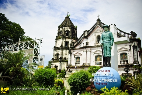
Bataan rings a chord in the heart of every Filipino. It is a symbol of democracy and freedom – a memorial to the gallant Filipino-American defenders of Bataan who fought decisive battles that delayed the timetable of the well-equipped and better trained Japanese Imperial forces, and changed the course of history in the Pacific.
Obscure and relatively unknown before World War II, Bataan was founded in 1754 by Governor General Pedro Manuel Arandia. The region was divided into two parts – The Corregimiento of Mariveles and the province of Pampanga. The towns of Mariveles, Bagac, Morong, and Maragondong, Cavite comprised the Corregimiento of Mariveles which was under the jurisdiction of the Recollect Order of the Roman Catholic Church. The province of Pampanga included the towns of Orion, Pilar, Balanga, Abucay, Samal, Orani, Llana Hermosa, and San Juan de Dinalupihan. The group was under the charge of the Dominican Order.
The Dominicans founded Abucay on June 10, 1588, Samal on April 30, 1641, Orion April 30, 1667, Orani and Balanga on April 21, 1714, Llana Hermosa May 8, 1756 and Pilar March 10, 1901. The three towns on the western side-Mariveles, Bagac and Morong were founded by the Franciscans in about 1578.
Bataan has more than its share of significant historical events: in 1574, the dreaded Chinese Limahong used Lusong point at the western side of Bataan as a landing place; in 1647, the Dutch Naval Forces perpetrated the Abucay Massacre; and the Bataan Death March to Capas, Tarlac started in the municipalities of Mariveles and Bagac. Today, touching commemorative shrines are dedicated to the memory of those who resisted the Japanese occupation – a bayonet thrust into the ground with a helmet symbolically slung over the riffle butt to mark the start of the Death March; and the imposing “Dambana ng Kagitingan” on top of Mt. Samat in Pilar, Bataan.
Bataan is a province faced with a challenge. It is on the verge of becoming both an extensive industrialization hub and a tourist haven which may well be the equivalent of the dynamic force it exuded in its historic past.
bataan
Location
Bataan is located in the southwestern part of the Central Luzon Region. It lies approximately at coordinates 120° 15' to 120° 40' latitude and 14° 20' to 14° 50' longitude. It is bounded on the north by the provinces of Zambales, on the northeast by Pampanga, on the west by South China Sea, and on the east by Manila Bay.
Climate
The climate in Bataan is categorized under Type I. There are two distinct seasons: the rainy season and dry season. The rainy season starts on the month of May and ends up around the month of October. The rest of the year is dry with occasional rains dispersed widely throughout the province. Occasional typhoons visit the area especially during the months of June to September.
Topography
Bataan is a mountainous land mass, dominated largely by uplands, hills, and mountains,covering 80.9 percent of its whole area. The lowlands and plains, which comprise 19.1 percent of the land area of the province, are generally flat, gently rising towards the hills. These areas comprise most of the agricultural portion of Bataan, found along the northern and eastern coasts facing Manila Bay.
Hydrology
The province is drained by numerous rivers and small streams with very few meanders radiating and sloping from the mountain groups down to the sea draining the whole area efficiently. There are more than one hundred rivers in the province which are very important not only for irrigation but also for purposes of navigation and fishing.
Geomorphology
The whole province of Bataan can be classified broadly with one volcanic terrain. Most of the highest elevations are considered parts of the collapsed caldera forming a ring-like structure with the suspected mouths, Mount Natib and Mariveles. Other high peaks are most likely the satellite vents of major volcanic craters presently occurring and dikes along the upper and mid-slopes of the volcano. Bordering these morpho-landforms are lava fields and flow plains with deep incision, steep cliffs, occasional gorges, and minor cascades.Coastal areas are classified by typical marine land forms such as beaches, ridges, swales, and foreshore sand bars.
Geology
Basically, Bataan is tectonically sitting directly on top of an active subduction zone, which centers along the Manila trench. It is believed that this zone was responsible for the Early Pliocene to Early Holocene period of volcanic activities giving rise to varied depositions of volcanic rocks in the whole peninsula.
There are three (3) rock strategic units exposed in the area, namely: quaternary pyroclastics (QP), quaternary plug (Qp) and quaternary alluvium (Qal).
Quaternary pyroclastics occupy the rolling to hilly ground with infrequent deep incision in several sections of creeks and rivers. It is composed of volcanic breccias, tuff and tuff breccias, and lahars.
Quaternary plug is made wholly of alticandesites rock.
Quaternary alluvium occupies the low- , lying areas which include the beaches and plains. These deposits are derived from weathering and erosion of older volcanic rocks that were later transported and deposited along stream channels.
Volcanoes
The presence of a chain of volcanoes in the Zambales -Bataan region, including the currently active Mt. Pinatubo, may put the province under threat of volcanic eruption. Mt. Pinatubo, some 40 kms. to the north, deposited a relatively thin but widespread ash cover over the Olongapo -Subic- North Bataan area during its last eruption. Similarly, the smaller, dormant volcanoes are Mt. Sta. Rita and Mt. Malasimbo.
These tectonic elements are probable earthquake generators that would trigger ground- shaking and ground displacement. Bautista, et.al. (1992) have conducted probabilistic estimate of peak ground acceleration. For the Bataan area, a ground acceleration value of 0.1 g (1 times the force of gravity) within a 50-year return period was estimated. In the same study, Bautista, et.al. suggested that the risk of tsunami along the coastal areas of Bataan cannot be discounted since tectonic features around Bataan are capable of generating tsunamegenic earthquakes. Historically, the occurrence of a tsunami in Bataan that has been last recorded was on December 7, 1677.
Based on the distribution of earthquake epicenters in the whole archipelago, the strongest is, in fact, the eastern section, i.e. Eastern Mindanao, Samar, and Leyte. However, other relative active parts are the vicinities of Lubang Island -Mindoro, the East Luzon Trench, Casiguran Fault, Digdig Fault, and the northern segment of the Philippine Fault Zone, all of which are within the 150-km. radius of the province.
Water Quality
Coastal marine waters support a dynamic ecosystem and contain valuable natural resources that are important to the coastal community. The inseparable relationship between land use and water quality are major issues in the coastal zone.
The Bataan coastal area is receiving drainage from immediate watersheds through tributaries and major river systems. Large amounts of waste drain into the coastal waters from domestic discharges.
With rapid increase in population and industrialization within the coastal area, water quality is expected to deteriorate. Contamination of the Bataan coastal and marine waters will continue to increase with the inevitable population and economic growth. The sources of contamination that eventually lead to marine pollution are domestic and industrial wastes, agro-chemical loading, siltation/sedimentation, toxic and hazardous wastes, and oil pollution.
